What to Know
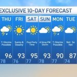
- A dangerous stretch of heat grips the tri-state area starting Tuesday, sending temperatures into the 90s. They’re expected to stay there for a solid week
- It’ll feel more like 100 for much of the week because of high humidity; NYC’s average number of days above 90 degrees in July is 11, five days more than the current total this year.
- Conditions could be perilous for especially vulnerable people and pets, so be sure to check on any older neighbors to make sure they are able to handle the hot weather.
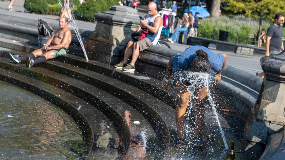
The first extended and brutal blast of summer hits the tri-state starting Tuesday, smothering people and pets alike with suffocating humidity as actual temperatures top the 90s. And there won’t be any relief for awhile.
A “cold” front passing through overnight opened the morning with some less humid air, but temperatures will rise over the course of the day. Expect a high around 92, which won’t be too bad compared with what’s ahead.
The mercury should climb to about 95 on Wednesday but it’ll feel like 100 or hotter with the humidity. That pattern is expected to linger through the weekend at least and possibly into Monday. Conditions could be perilous at times, for especially vulnerable people and pets, so be sure to check on any older neighbors to make sure they are able to handle the hot weather.
A heat advisory is in effect for New York City. Any resident who needs a place to keep cool should look for the nearest cooling center in their neighborhood. Check the latest severe weather alerts.
New York City’s average number of days above 90 degrees in July is 11, five days more than the current total this year. The heat wave will eclipse that mark by the time all is said and done.
NYC had its official heat wave of the summer last week, with Thursday being the third straight day in the city where temperatures hit 90 degrees or above. This heat wave will be even hotter and possibly more than twice as long.
Gov. Kathy Hochul issued a statewide warning on the heat before the latest wave started, saying on Monday, “The next several days will bring extreme heat throughout the state with dangerous heat indices potentially reaching into the 100s.”
“I am urging all New Yorkers to prepare for heat and humidity this week and to keep a close eye on the weather over the next couple of days,” the Democrat added. “As New Yorkers, we take care of one another, so please don’t forget to check on neighbors, especially seniors, those with young children, and people with disabilities.”
The New York State Department of Health also reminds New Yorkers that heat is the number one weather-related killer in the United States. Heat-related deaths and illnesses are preventable, yet annually many people suffer from the effects of extreme heat. Some individuals are at a higher risk for heat-related illness than others.
New Yorkers should learn the risk factors and symptoms of heat-related illness to protect themselves and those they love.
Symptoms of heat stroke include:
- Hot, dry, red skin
- A rapid pulse
- Rapid and shallow breathing
- A body temperature higher than 105°
- Loss of alertness, confusion, and/or loss of consciousness.
Learn more and find cooling center locations here.
Track any approaching weather using our interactive radar below.
The heat wave follows a storm system that triggered a bevy of flash flood and thunderstorm warnings throughout the New York City area on Monday, with floodwaters impacting commutes for many throughout the tri-state.
A record amount of rain fell at Central Park throughout the day on Monday, with 1.85 inches recorded — breaking the daily rainfall record of 1.76 inches previously set in 2012.
Damaging winds and heavy rain thrashed much of the tri-state area late Monday afternoon, including New York City.